Summer of smoke: Across the Great Basin
Between the eastern edge of California and Nevada’s Great Basin, the long flat miles of desert country are measured by landmarks: a tree filled with shoes, a rusted water tank, a black mailbox.
Leaving Tonopah, Nevada, and just past the bowling alley in the shade of a mountain is a landmark – the familiar weathered outbuildings of Bobbie’s Buckeye Bar. The painted silhouettes of women whispering behind half-drawn window shades, have quietly faded into the siding on the windowless ends of the defunct brothel’s bunkhouses.
Tonopah quickly disappears behind me as I straight-line across Ralston Valley past Tonopah Speedway and dilapidated World War II-era hangars which mark the northern perimeter of the Nevada Test and Training Range.
The distance between gas stations here is 172 miles, just about the number of miles that make my amber reserve light come on. The one-gallon RotoPax gas canister I bought specifically for this stretch is locked to my tail rack beneath my soft bag.
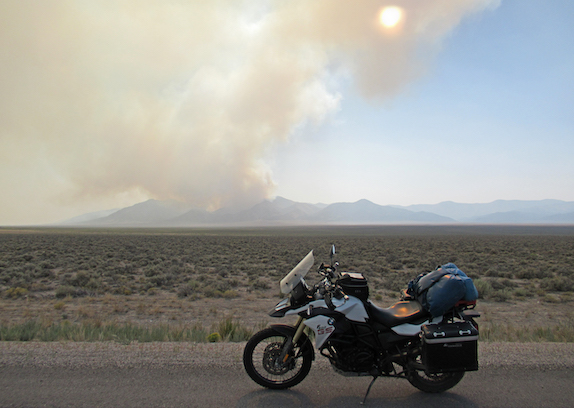
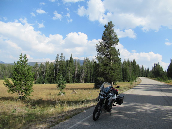
Mountains and gently rolling valleys, the basin and range country surround me, beautiful and desolate, a palette of earth tones and smoky sky. Human presence is minimal. A small, scattered herd of wild horses graze peacefully on a side hill above Five Mile Ranch. The white ranch house with red trim must be a hundred years old, its porch cluttered with boxes and things. Several pickup trucks are parked between corrals, but no one’s around. I roll along, across long basins, through passes between rugged burnt orange and brown ridges. Several miles up the road, past the turnoff for the ghost town of Tybo, I stop at a rest area to drink some water, eat an apple and take a picture of my motorcycle.
Tall cottonwoods clustered with dense green leaves shade the house at Black Rock Station. A spring feeds marshlands that fans out across the alluvium, surrounded by stark desert. A car is parked on the southbound side of the highway. Next to it, a couple watches a small herd of wild horses, all ivory black, four adults and three colts turn and walk across the arid landscape to the shelter of the Pancake Range. Once past the shade of the cottonwoods, Railroad Valley, is long, yellow, dry and flat, walled in by distant brown mountains.
The smoky skies are gone in Ely. I check in to the basic but comfortable Motel 6 with an expansive view of the Schell Creek Range, then walk two blocks to the Fiesta Mexican Restaurant for dinner. I was happy to be riding again and didn’t know how it was going to go on a long trip. Recovery from knee surgery was not as fast I would have liked. In mid-July the Ferguson Fire started burning west across the Sierra, spreading a thick, choking pall of smoke upon the Owens Valley and creating endless overcast skies. The summer riding season was slowly evaporating. To make up for days of lost riding, I decided to go to the Beartooth Beemer Bash in Red Lodge, Montana. It was a destination, a reason to ride.
After a cup of Motel 6 coffee, I packed up and rode north across the Steptoe Valley, one hundred and forty miles to Wells. Vast sagebrush-grasslands and north-south trending mountain ranges parallel the highway. Closer to Wells, metal buildings and manufactured homes have popped up quickly across large swaths of grasslands, prime pronghorn antelope habitat. Smoke has covered the sky, drifting east from the Mendocino Complex and Carr fires, burning in Northern California. In Wells, I stop at Bella’s for breakfast, arriving at 9:30 after the morning rush of travelers.
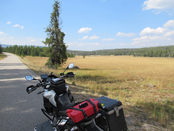
From Shoshone, Idaho, I take the Peaks to Craters Scenic Byway, a narrow, two-lane road sandwiched between the southernmost edge of three mountain ranges – Sawtooth, Lost River and Lemhi – and an uninterrupted vista of umber-colored volcanic flow, topped with sagebrush and grasses. Outside of Arco where I’ll spend the night camping at the KOA, I stop to look at the dry Big Lost River and the remains of a stone cabin.
The first warm light of morning drifts across the mountains and filters through the meadow grass in the field beyond my tent. I boil water for coffee and oatmeal on my camp stove, while packing, then ride into town and top off my tires with air. I chat with a rider returning from Sturgis, then ride east across the flatlands of Idaho National Laboratory into the sun, a deep orange ball hovering above the highway in a dense smoke-filled orange sky. Listening to music and Google Maps on my Sena while glancing at my handlebar-mounted Garmin, I bypass downtown Idaho Falls and sweep into the rolling hills and wheat fields of Swan Valley. From the Snake River where fly fisherman cast from their dories, my route turns up the Teton Scenic Byway, and steeply climbs and curves into the tall pines of the Targhee National Forest, across Pine Creek Pass into Victor, then up and over Teton Pass and down to Jackson, Wyoming. Moose-Wilson Road is open so I take it into Grand Teton. It is mostly paved now, though often closes this time of year when bears come down to eat berries.
A faint smoky haze permeates every part of the park, accentuating the distance between foreground forests and the high peaks of the Tetons, in a painterly way. Past the traffic circles, the road ebbs and flows through the forest, along the Snake River to Jackson Lake, then on into Yellowstone.
South of Old Faithful, a man in his late 20s carrying a faded orange Camp Trails Skyline backpack and sporting a well-worn baseball cap is walking in the middle of the road, with both hands raised and middle fingers extended, yelling at the cars. I see his mouth moving but can’t hear what he is saying. The car in front of me slows down and the guy starts moving my way. “Oh no,” I’m thinking, but squeak by him. Five minutes later, a park ranger zips by in a SUV, lights on and sirens blaring.
I spend a cozy night in West Yellowstone in a vintage motel along the edge of the national park. My plan was to have breakfast in Cooke City, ninety miles away. In the morning, I followed the lovely Madison River back into Yellowstone. A few cars and a group of Harley Davidson riders lined up behind me, but I stuck to the 45 MPH speed limit. When a doe darted from the bush, I hit the brakes and paused for a few seconds – then the fawn ran out. Everybody backed off after that.
At Tower Junction, dozens of tourists swarmed a small group of buffalo, abandoning their vehicles in the road, blocking both lanes of thru traffic. “How lucky,” I thought, “that the Beartooth is this way,” and went in the opposite direction. It was a fun ride, up and down a curvy grade, past the Grand Canyon of the Yellowstone, and along a wide river. None of it looked familiar. A sign for Cody, Wyoming prompted me to stop and check my maps. I was paralleling the Yellowstone River, not the Lamar. I wondered where all the buffalo were. I had turned south instead of east at Tower Junction – a 60-mile round-trip detour, but really, just another beautiful ride.
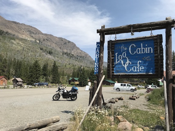
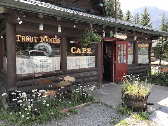
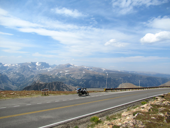
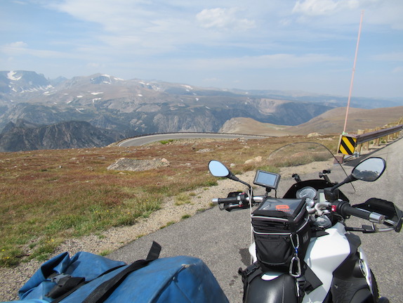
It was 2:30 PM when I stopped for lunch at the Log Cabin Inn in Silver Gate. From there, the Beartooth Highway climbs 3300 feet to alpine meadows via a series of long straightaways and hairpin curves – a complete high-altitude experience: steep drop-offs, rocky walled cliffs, glacial lakes, patches of snow, distant crags, mountain tops, big sky and thin clean air. It’s as close as you can get to mountaineering from the back of a motorcycle. Over the pass, the curves tighten and the drop-offs are sheer on the descent into Red Lodge. The elevation drops 5,000 feet to the canyon bottom where the road straightens out to Red Lodge. It is in this beautiful river canyon that the Beartooth Beemers were celebrating their 20th anniversary.
The rally is held at the Lion’s Club Youth Camp, a collection of cabins with a dining hall along a forest meadow surrounded by the Beartooth Mountains and Custer Gallatin National Forest. I spent four nights camped near a creek beneath tall pines. The first day, a moose cow and her calf ambled by along the creek. The setting is beautiful and the area riding is well-known. Volunteers from the Lion’s Club are in the kitchen each morning by 4 or 5 AM, making coffee and starting breakfast. They cook all day long.
The days were warm and sunny with only one famous Montana deluge the day before the rally ended. Snow closed Beartooth Pass Sunday morning. I had planned to ride over the pass, but decided to loop north to the interstate. People asked me where I was going next, and when I told them Jackson, Montana, one woman said, “You better take a big man with you.” Not sure what she meant and she slipped out of the room before I could ask.
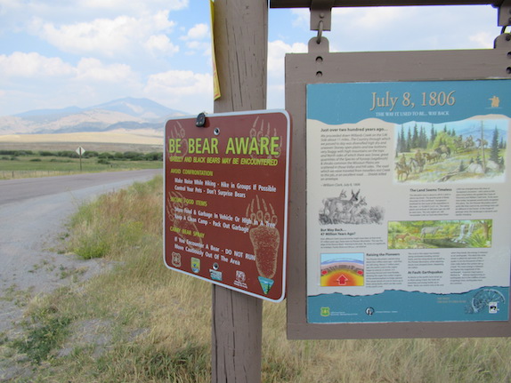
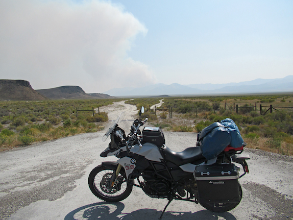
The two-lane road from Red Lodge to Absarokee meandered through gently rolling hills – lots of big ranches. At one point, two white tail deer leapt through tall grass along the highway beside me. I picked up the interstate to Bozeman, then down to Ennis and across Virginia City. New multiple fires had started all over western Montana and Eastern Idaho. I passed several firefighter base camps.
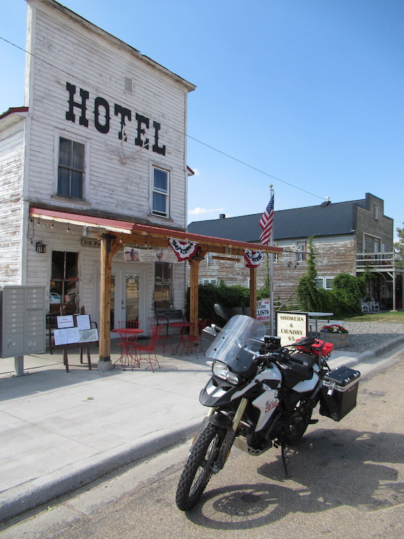
From Dillon, I rode east to Jackson, one of Montana’s great little towns. Jackson is known for its hot springs; it is said Lewis and Clark once boiled elk meat in its waters for their dinner. I checked into the Bunkhouse Hotel (built in 1910) and with the exception of updated “down the hall” plumbing and bright red walls, it was pretty close to original. Five Texans, fly fishermen claimed the second floor, which was one great room with five queen beds and a bar on one end. Next to the Bunkhouse, one could get a home-cooked meal at Rose’s Cantina.
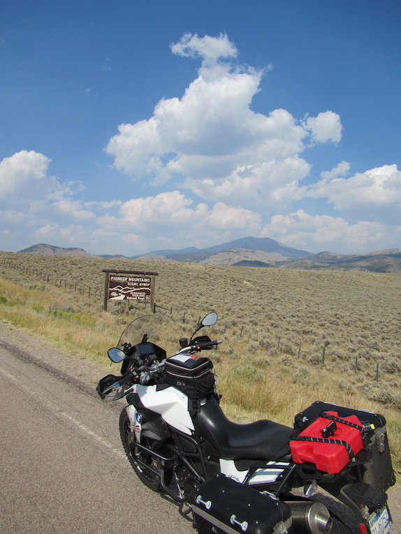
On the way in, I passed a USFS Scenic Byway through the Pioneer Mountains. A forest service ranger was posting fire status updates on a board outside the hotel, so I asked her how long it would take to ride the byway. She said two hours, so I left all my gear in my room and headed back down the highway and has a beautiful afternoon ride through the Pioneer Mountains. I saw two herds of pronghorn antelope grazing in sagebrush near Polaris. Between Wise River and Wisdom, along the Big Hole River, I didn’t see another vehicle. I stopped in Wisdom to fill up with gas and discovered there was no credit card slot in the pump. I turned around to go inside, but the store had closed two hours ago. My gas canister finally paid off. A local later told me there was one pump at that station with a credit card slide.
I was to start home the next morning via the Sacajawea Scenic Byway through Idaho, but serious Red Flag warnings were in effect – high winds of 45-55 MPH along that route, which is quite exposed. Instead, I rode into Dillon, filled up with gas, then rode back out to Bannack State Park. My last visit there in 2011 was before a flash flood ripped through the park. Restoration was almost finished, so I spent an hour exploring the town. A storm was coming in with high winds, so I started back to Jackson. It was pouring rain by the time I got back and rained all night. Had an early dinner at Rose’s then retired to my room to read. As the night progressed, the three vacant downstairs bedrooms filled with guests and I could hear them talking outside my door. One guest had been caught in a forest fire hiking the Continental Divide Trail and was evacuated. Another was riding the Trans-America Trail, and thought he was going to have to bed down in fields 10 miles outside of town because of wind.
Next morning, I started out towards Salmon, but two miles out of town got stuck behind a cattle drive of at least a thousand head of black Angus. I asked the woman driving the sweep vehicle if they were going all the way to Wisdom, and she said, “Oh no,” and named a road not too far ahead. “Do you know that road?” she asked. “No, don’t know that road, but thanks.” I stayed back, about 150 feet behind the line of cowboys and dogs. There was no way I was going try to ride through a mass of cattle and be mistaken for a cowboy on a horse. Trampled cow manure turned to airborne mist in the light rain, coating everything that followed. My tires and undercarriage were golden greenish-yellow. When one or two energetic cows broke away from the herd and headed towards me, I held still – the border collies were on it. Six or eight dogs would surround the cow and work it right back to the herd.
A little over an hour later, rolling along at cow speed, the cows, dogs, cowboys and horses turned off the highway. I went on to Salmon, where I met the Sacajawea Historic Byway, an out-there 122-mile stretch of straight road through a long valley between the Lemhi and Beaverhead mountains. I passed two more cattle roundups, and a group of Jeeps heading out to the Lemhis. The road terminated at Mud Lake on Highway 33, and from there I started back home, following the same beautiful route I always take when I go this way, through the Great Basin back home to California.