Byway or the highway
Under a star-filled Colorado sky in the dwindling glow of the last embers of the evening’s campfire, we crawl into the quiet solitude of our tents and begin laughing at the crazy cacophony of the daily sixty-plus unzipping and zipping actions which make up our nightly retreat and morning reveille. Welcome to Zipper Tour 2019!
Aside from this daily YKK symphony of tents, clothing, bags and boots, spending a week motorcycle camping in the Colorado high country provides complete serenity and rejuvenation for one’s soul. Each night, as we sat around the campfire, my traveling companion Joe Farrell and I would calmly reminisce over the days adventure and share our appreciation for how fortunate we are to be living and riding in this glorious land.
The state of Colorado, home to some of America’s most beautiful scenery, has graced us with 26 Scenic Byways allowing us to experience and marvel at this majestic landscape surrounding us. In early spring of 2019, Joe and I decided to try and link together as many of these byways as a week-long tour of the Colorado high-country would allow. We accessed Colorado’s many online tourist resources and other related websites and discovered that Scenic Byways tend to be mashups of smaller secondary roads linked together to form the named route.
Because we were riding heavily laden BMWs with street tires, we wanted to avoid the many dirt and gravel roads in the region. We did extensive route planning to familiarize ourselves with the various roads and turnoffs, often using local expertise to verify road conditions. The popularity of our destinations made it wise to arrange many of our campgrounds ahead of time and because our departure date was in prime bear foraging season, we decided to eat out rather than bring food along. In late July, we packed the bikes, loaded the navigation systems and were on our way.
Day 1: July 23 – Snowmass Village to Estes Park – 247 miles
We left Snowmass Village at 7:45 a.m. and headed northeast toward Estes Park in Rocky Mountain National Park. We rode through the White River National Forest on the Top of the Rockies Scenic Byway, rarely dipping below 9,000 feet. This 75-mile, high altitude route begins in the historic mining town of Aspen on its way to Leadville before we opted for the eastern branch to Copper Mountain.
Just below the Continental Divide on the constant, twisting climb to Independence Pass, we arrived at the historic ghost town of Independence. It was here, in 1879, where gold was first discovered in the Roaring Fork Valley. Independence sprung up as the first mining site and today, the ghost town is a historical preserve.
Independence Pass, a very popular destination along the byway, is well above tree line and surrounded by hills and meadows of fragile, grassy tundra. Cresting the pass, we rode through switchbacks and sweepers to last winter’s avalanche debris fields. The massive snow fields above us had collapsed and sent hundreds of huge aspen and pine trees downhill where they raced across the valley floor and shot far back up the opposite mountain side. The destructive power was awesome.
A few miles on, arriving in the town of Twin Lakes, we rode north to Leadville. The highest incorporated town in the U.S., Leadville was also the perfect spot for a breakfast break. After enjoying burritos and fresh coffee at City on a Hill, we refueled and were on our way. Taking the eastern branch of the Top of the Rockies, we followed the scenic East Fork of the Arkansas River, rising over Fremont Pass (11,318 feet) to Copper Mountain Ski Resort, where the byway ends.
At Copper, we headed to Silverthorne and rode along the Blue River through the Arapaho National Forest, past Green Mountain Reservoir, to the silver town of Kremmling. Here, we joined the Colorado River Headwaters Scenic Byway and rode beside the mighty Colorado River passing through the Three Lakes Reservoir region to Grand Lake. Surprisingly, on this portion of the byway, the “raging” Colorado River often resembled a relaxing brook, gently tumbling down meadows and rock faced falls. At about midway along this route, the air filled with a telling aroma, and we knew we were arriving in Hot Sulphur Springs.
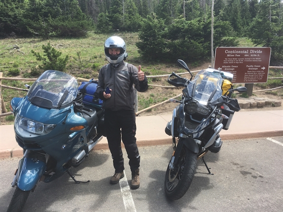
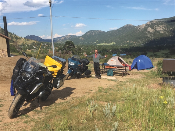
At Grand Lake, in Rocky Mountain National Park, we arrived at the beginning of the Trail Ridge Road Scenic Byway, one of Colorado’s most popular roads. This 48-mile byway is America’s highest continuous highway, climbing over Milner Pass (10,759 feet), over the Continental Divide and Iceberg Pass (11,827 feet) before descending toward our destination at Estes Park and Mary’s Lake campground.
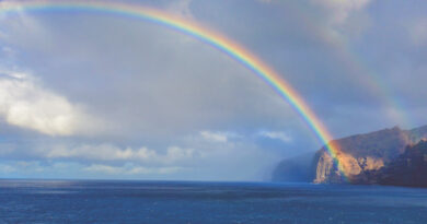
We set up camp accompanied by our first official overture of “The Zipper Tour” symphony and, after the musical interlude, headed to town for fuel for the bikes and ourselves. Soon after leaving camp, the skies opened, but once the storm passed, we were gifted with our first double rainbow of the trip. After dining at The Rock Inn Mountain Tavern, we returned to our slowly drying camp for libations around the campfire before another musical interlude and bed.
Day 2: July 24 – Estes Park to Echo Lake Park – 146 miles
The next morning, Joe awoke to my playing the second movement of the YKK Bolero, and we were up with the sun. But as the tents were still damp from the storm the evening before, getting organized and repacking the bikes took a little longer than anticipated.
Our initial plan was to follow the Continental Divide out of Estes Park through abandoned ghost towns along the scenic and twisty Peak to Peak Scenic Byway to Idaho Springs. We would get on the Mount Evans Scenic Byway to Echo Lake Park and ride up to the summit of Mount Evans.
On the Peak to Peak, passing through some of Colorado’s most popular destinations, we soon crossed over Wind River Pass (9,130 feet) and rode to the Chapel on the Rock near Allenspark. It was here, in 1993, during his World Youth Day visit that Pope John Paul II prayed and hiked along the trails of the Saint Malo Retreat. We continued south to the old trading post town of Nederland, where we had a late breakfast at the New Moon Bakery and Cafe. Beyond Nederland, we were seduced by the allure of Golden Gate Canyon Road, and instead of arriving in Idaho Springs, we found ourselves, much later, in Golden. Here, we regained our bearings and headed west along Clear Creek, passing through six rocky tunnels to find our way back to Idaho Springs.
Skipping the interstate and following the scenic route, we rode Evergreen Parkway to Mount Evans Scenic Byway in the Arapaho National Forest. We climbed over Squaw Pass (9,790 feet) and Juniper Pass (11,020 feet) to arrive at our destination, Echo Lake Park campground.
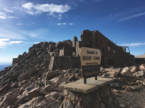
At Echo Lake, not reservable in advance, we were fortunate to get one of the last walkup spots for this evening’s stay, as it was again beginning to drizzle. We quickly got to setting up camp, because the planned highlight of the day was to ride to the summit of Mount Evans (14,258 feet). Climbing 7,000 feet in 28 miles, this is the highest paved highway in North America. We didn’t let the weather dampen our excitement as we eagerly, through rain and drizzle, headed up the frost-heaved road to the summit.
While the views were compromised by weather, the ride up was exhilarating, and we witnessed some “high-altitude” truck testing of heavily camouflaged pick-up trucks from an unnamed vehicle manufacturer. At the summit, we were entertained by numerous mountain goats and a big horn sheep welcoming committee. Here, we decided the many “road damage” signs should refer to “goat damage” as the critters were all busy at the side of the road digging for road salt residue and undermining it in the process. While the wildlife stayed busily working, we and the stealthy truck’s all carefully headed down the rain slicked road from the summit.
That evening, the nearby Echo Lake Lodge provided a fine dinner hosted by our waiter, Lucas, a student from the Czech Republic. Afterward, we took a short sunset walk down to tranquil Echo Lake so Joe could verify the echo, of Echo… Echo… Echo Lake… before returning to camp to enjoy a sip of whiskey, a can of beer and a crackling campfire. Then zip… zip… zip, and into our tents.
Day 3: July 25 – Echo Lake Park to Colorado Springs – 198 miles
As the weather was more hospitable this morning, we realized it would be better to take our scenic rides early in the morning to avoid the regular afternoon showers. So, before packing up camp and traveling back over Squaw Pass to Pikes Peak toll road, we again rode Mount Evans Scenic Byway.
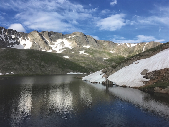
The ride up was glorious, and except for the goats, we were alone at the summit. While it was 46 degrees at 7:45 a.m. this morning, it didn’t keep us from enjoying the spectacular western views of the Rocky Mountain peaks and to the east, beyond Denver, the Great Plains. Soon the general public began to arrive, and we rode down the twisties, enjoying thrilling views of the cliffs and peaks as the sun danced between shadow and light above timberline.
Stopping at Summit Lake Park which, at 12,840 feet, anchors the high-altitude end of the Denver Mountain Parks system, we walked out to the cliff’s edge, joined only by Big Horn Sheep. We had stellar views of the naturally formed glacial lakes and the far peaks. At tree-line, the Mt. Goliath Natural Area featured crazily shaped trees “flourishing” in their windswept and desolate environment,
Still early in the day, we packed the bikes and enjoyed “everything omelets,” at the Echo Lake Lodge before heading to Pikes Peak via a short portion of Colorado’s only urban byway, Lariat Loop Scenic Byway, which, passes through the towns of Denver’s Mountain Area.
Traveling through the Arapaho National Forest at Evergreen, we rode CO 73S, a fun, curving road beside Cub Creek. At Conifer, we followed the North Fork of the South Platte River into Pike National Forest and the town of Deckers. We biked through the meandering canyons of CO 67S into Woodland Park, and there we cruised along US 24E into Manitou Springs.
Manitou Springs, in the shadow of Pikes Peak, is home to eight uniquely flavored, naturally carbonated mineral springs not found anywhere else in Colorado. We opted to dine at Joe’s highly recommended Vienna Station, where Old Colorado City’s only hot dog stand serves up “Best of the Springs” Chicago Style Hot Dogs. Sitting outdoors with Pikes Peak in the background, we watched as it became completely covered in storm clouds. Soon, lightning flashes through the clouds were all we could see of the summit. Camping seemed less attractive at the moment, and we decided to stay nearby in Colorado Springs at the Travelers Uptown Motel. This gave us a chance to clean up and be “more presentable” as we walked around town. The weather in town held off, and we had dinner at Rasta Pasta. Back at the Travelers Uptown, with no musical accompaniment this evening, we were soon in “The Land of Nod.”
Day 4: July 26 – Colorado Springs to Alamosa – 261 miles
Up early the next morning, we found the weather crystal clear. We packed the bikes and after a coffee and donut at the motel, headed to the nearby towering sandstone formations of Garden of the Gods. This free, city-owned park is a National Natural Landmark formed millions of years ago during upheavals in the earth’s surface. The park is where grasslands of the Great Plains merge with the mountain woodlands of Pikes Peak. Riding multiple internal loop roads, we enjoyed the distinctive red-rock formations which form one of the world’s most incredible geological wonders before heading to Pikes Peak.
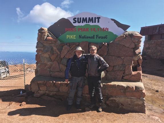
Taking advantage of the weather, we then rode north to the very popular Pikes Peak Toll Road Scenic Byway. This 12-mile byway climbs to the top of the world’s second most visited mountain summit. Traffic was already backed-up at the entrance, but we, with the help of a nice ranger lady, were through and on our way in just a few minutes.
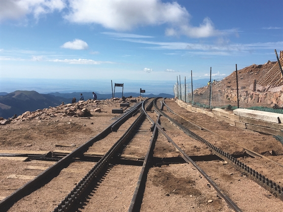
Pikes Peak toll road is a fun, windy road up through the tree line, taking in spectacular scenery as the road finds its way to the summit. Due to a 50-million-dollar construction project at the summit replacing the present Summit House and upgrading the 125-year-old Cog Tramway, we were not able to officially “summit” but took the free shuttle a few miles to the top. The view here inspired the song “America the Beautiful,” written in 1893 by Katharine Lee Bates after having reached the summit of “America’s Mountain.”
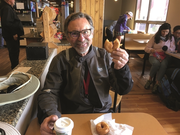
Inside the Summit House, Joe and I were seduced by the world famous “high altitude donuts.” The line for these little delights went all the way out to the entrance. Legend has it, if you purchase these at the summit and bring them to the base of the mountain, they flatten, like bagel chips, from the increased atmospheric pressure. But, we found them too irresistible to test the veracity of that legend.
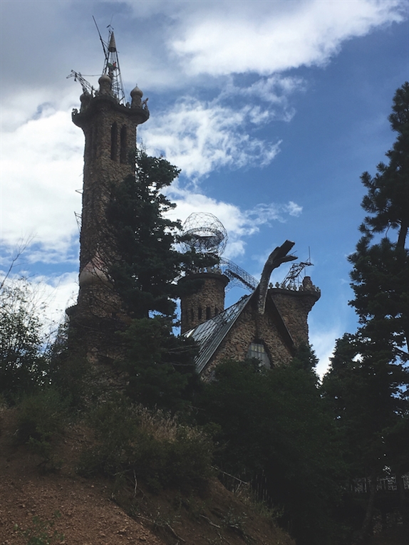
Remounting our bikes at the Devil’s Playground shuttle stop, we headed toward a portion of the Frontier Pathways Scenic Byway in the San Isabel National Forest, passing landscapes from mountain to desert on our way from Wetmore to Colorado City. Along the way, near Rye, we stumbled upon the famous Bishop Castle. Free, and open to the public, the castle is a monumental statue of stone and iron. Jim Bishop built his dream of medieval fantasy, stone by stone, over the past 50 plus years, and it is a testament to what one determined man can accomplish.
After a tour of the grounds, we headed to Colorado City and Walsenburg where we rode a short portion of Highway of Legends Scenic Byway. We enjoyed dazzling views of the Spanish Peaks in the nearby San Isabel National Forest. We continued onto the Los Camino Antiguos Scenic Byway, through thunderstorms and hail, toward our destination at Alamosa.
As we approached the Great Sand Dunes National Park, it was wet and getting late, so we decided to visit the following morning and go directly to our campground near Alamosa instead. Fortunately, our camp at the KOA was completely dry and very comfy. Our hosts, Joe and Jeanette, were most gracious and delivered firewood and excellent pizza to our site. Made a fire, ate pizza and… Zip Zip Zzzzzzip…
Day 5: July 27 – Alamosa to Durango – 268 miles
The sky was clear again this morning, and after a complimentary breakfast at the Alamosa KOA, we backtracked to the Great Sand Dunes National Park on the eastern edge of the San Luis Valley. The tallest dunes in North America, they cover about 30 square miles. More than simply a misplaced ocean shoreline, the preserve contains four separate and unique ecosystems within the mountain watershed and is home to several insects found nowhere else on the planet. Hiking is permitted throughout the dunes, and we used Joe’s binoculars to see the “adventurous ants” crawling along the hills.
We followed the call of the Los Caminos Antiguos as we explored the small towns of the San Luis Valley, Manassa (birthplace of prizefighter Jack Dempsey, the “Manassa Mauler”), Romeo and Antonito before dropping into New Mexico over La Manga Pass (10,230 feet) and Cumbres Pass (10,022 feet) through the Rio Grande National Forest.
At the Box Car Café n Chama, Marissa, served us a delicious lunch under a canopy of shade trees, consisting of authentic tacos, rice, beans and sopapilla. This is where they say it’s “Made in Chama—NOT China!” Refreshed, we continued up through the Rio Grande and San Juan National Forests through Pagosa Springs to Durango.
Seven miles east of Durango, we set up camp at KOA East and went into town to explore. Our visit happened to coincide with “Durango Fiesta Days,” and the town was abuzz during this week-long celebration of the rich history and heritage of the Durango area. The town was founded by the Denver & Rio Grande Railway in 1879 and began passenger and freight service to Silverton in 1882. The historic Durango & Silverton Narrow Gauge Railway has been in continuous operation since that time. Nowadays, it carries sightseers, using vintage steam locomotives and rolling stock through the splendor of the San Juan Mountains.
We each had a delicious steak salad for dinner, at the Lone Spur Cafe. Back at camp, we relaxed by the fire and relived the days adventures, before zipping to sleep.
Day 6: July 28 – Durango to Crawford State Park – 186 miles
After we made quick work of another pancake breakfast in the Caboose Cafe, courtesy of KOA, we packed the bikes and were northbound on the San Juan Skyway Scenic Byway, passing through some of southwest Colorado’s most historic places. The route rises through the San Juan National Forest and over Coal Bank Pass (10,640 feet) and Molas Pass (10,912 feet), eventually dropping into the valley region toward Ridgway.
Stopping in Silverton, there was a lot of excitement as the narrow-gauge Durango and Silverton railway’s #476 steam engine from Durango had just arrived. Silverton, being smaller than we expected, probably calms down pretty fast once it departs. After admiring the train, it took us a while to figure out how to get out of town. We tried a few promising leads, but eventually figured out there was only one paved road into and out of town.
Backtracking to the skyway, we continued north over Red Mountain Pass (11,018 feet) toward Ouray. This steep stretch of byway has several gorgeous overlooks, twists and hairpin turns bordered by waterfalls, huge cliffs and mountain slopes littered with mine tailings. Descending this beautiful path, we discovered Ouray was much larger and more bustling than we had imagined. It might be called Colorado’s version of “Moab” as the streets were filled with people, dirt bikes, road bikes and 4-wheelers of all sizes. Feeling hungry, we worked our way through the crowds to find two seats at Maggie’s Kitchen on Main Street where we chowed down on two huge, green chili and cheese burgers.
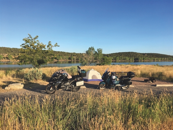
Departing Ouray, the mountains and cliffs gave way to ranch land, farms and horse country. The ride to Delta was much flatter and more developed than we had expected or had experienced during our trip. But once we reached Hotchkiss and were on the West Elk Loop Scenic Byway, the thrills returned. The short ride from there to our destination at Iron Brook campground in Crawford State Park consisted of dazzling scenery, mountain ranges and alpine wildflowers. The farms and cattle ranches reminded us of those who once lived and those who now live here.
It was dry, hot and sunny as we arrived at the state park. Our campsite overlooked Crawford Reservoir, and Joe took a refreshing dip. In the nearby small village of Crawford, where English singer Joe Cocker had established his ranch and restaurant, we ate at Diamond Joe’s Cafe and Saloon.
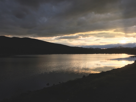
In camp that evening, we enjoyed a beautiful sunset beyond the reservoir and refreshments by the campfire. We talked about how quickly the week had zipped by and how fortunate we were to live in Colorado and able to ride these wonderful byways. As the sun and campfire dimmed, we crawled into our tents and were saddened that the “Zipper Tour” was coming to an end.
Day 7: July 29 – Crawford State Park to Snowmass Village – 198 miles
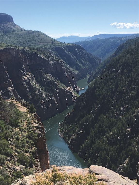
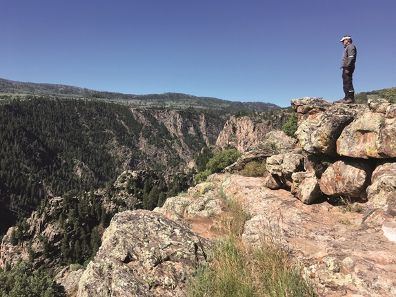
The sun rose beautifully bright on our last morning, and after surviving Joe’s camp coffee, we stopped in Desperado’s Market for breakfast burritos. The West Elk Loop brought us through the Black Canyon of the Gunnison National Park. There is no other gorge in North America combining the narrowness, depth and sheer drop-offs of the Black Canyon along the Gunnison River. After taking in gorgeous views and walking the roadside overlook trails, we rode past Blue Mesa Reservoir, in the Curecanti National Recreation Area, and stopped at the Elk Creek Visitor Center. At Gunnison, a town which once had dreams of being Colorado’s state capitol, we rode north on the Gunnison Taylor Park Loop scenic drive toward Crested Butte.
The historic district of Crested Butte contains many colorful Victorian buildings which preserve the aura of the past. In the summer, the surrounding meadows produce so many wildflowers, the Colorado legislature named it the “Wildflower Capital of Colorado.” In the downtown historic center, we lunched at the Brick Oven Pizzeria and Pub. On the menu, they offered an “authentic” Philly Cheesesteak. With my City of Brotherly Love roots, I knew I shouldn’t test the authenticity. But surprisingly, their presentation and product brought back memories of Pat’s, Geno’s and Lee’s from the old neighborhoods.
After lunch, we checked the weather and heard from locals that the dirt road over Kebler Pass (10,007 feet) was open and in good condition. Since we were both riding on street tires, we were worried how the heavy bikes would behave in the ruts, dirt and gravel. But, since the alternate route was hours out of the way, we decided to venture forth, on County Road 12, and find out.
The West Elk Loop Scenic Byway, CR 12, out of Crested Butte is a gentle meandering ride through Gunnison National Forest. We rode half of this 205-mile loop from Gunnison to Carbondale by way of Crested Butte. While there were some loose sections with lots of dust and a large flock of sheep in the road, overall it was easily managed by us both. After 34 miles though, we were glad to be back on pavement at Paonia Reservoir. We turned north and climbed over McClure Pass (8,755 feet) to the end of the West Elk Loop Scenic Byway at the base of Mount Sopris in the town of Carbondale. Less than 30 miles from where we began, we didn’t want our adventure to end, so took our time traveling the familiar back roads, the “long way around,” to our starting point in Snowmass Village.
Home again
I waved goodbye to Joe as he pulled into his driveway where he was greeted by the only bear we saw on the trip. The startled bruin quickly scampered up the nearest pine tree and under his watchful gaze, supervised as Joe cautiously unpacked his gear.
What a ride it was! Seven days and six nights of adventure, 1,500 miles ridden, 14 mountain passes, 13 scenic byways and many points of interest. We experienced some of the most diverse and beautiful scenery available in the United States. Each evening and every dawn we recognized how fortunate we are to live and ride in America’s most beautiful playground.